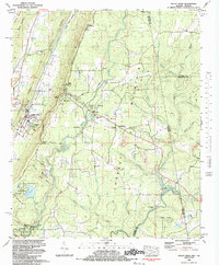
1983 Map of Valley Head
USGS Topo · Published 1983About this map
Valley Head sits at the base of Lookout Mountain, where the Southern Railroad follows the floor of Dugout Valley. The landscape is defined by the dramatic descent of the West Fork Little River toward De Soto Falls, a central feature of De Soto State Park. The plateau top around Mentone shows a blend of seasonal recreation and established local life, evidenced by Camp DeSoto and the Moon Lake Sch. Along the mountain's eastern edge, the topography transitions into the drainage basins of Middle Fork Little River and Lookout Creek. Cultural landmarks like the Sally Howard Mem Ch and Holly Spring Cem anchor the rural communities of Alpine and Bankhead. Small-scale industrial activity is noted by a Strip Mine near Anna Branch, while the Comer Scout Reservation preserves large tracts of terrain around Lake Republic.
Find a feature on this map
68 named features on this map. Tap any name to fly to it.
Don’t see what you’re looking for? This feature index may not catch every label — zoom into the map to look around manually.
Map Details
Editions of this 1983 Valley Head Map
This is the sole edition of this map. No revisions or reprints were ever made.
Other maps of this area

1886 · Ringgold
USGS Topo · 1:125,000

1886 · Rome
USGS Topo · 1:125,000

1886 · Stevenson
USGS Topo · 1:125,000

1892 · Ringgold
USGS Topo · 1:125,000

1892 · Stevenson
USGS Topo · 1:125,000

1893 · Fort Payne
USGS Topo · 1:125,000

1895 · Stevenson
USGS Topo · 1:125,000

1898 · Rome
USGS Topo · 1:125,000

1898 · Fort Payne
USGS Topo · 1:125,000

1899 · Rome
USGS Topo · 1:125,000