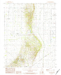
1984 Map of Valley Ridge
USGS Topo · Published 1984About this map
Crowleys Ridge rises distinctly above the flat Missouri Bootheel, defining the local geography of Dunklin County in the early 1980s. This landform serves as the backdrop for several small settlements, including Bethany, Valley Ridge, and the town of Campbell at the southern edge of the survey. The transition from the elevated ridge to the lowland plains is marked by the St Louis Southwestern railroad line and the engineered drainage of the Main Ditch, illustrating how the region's agricultural productivity was carved out of the wetlands. To the east, the Malden Municipal Airport and the Malden Corp Bdy indicate the expansion of local infrastructure and aviation. Small Cem markers scattered across the terrain provide valuable clues for genealogists tracking family history in Union township and the surrounding rural landscapes.
Find a feature on this map
11 named features on this map. Tap any name to fly to it.
Don’t see what you’re looking for? This feature index may not catch every label — zoom into the map to look around manually.
Map Details
Editions of this 1984 Valley Ridge Map
This is the sole edition of this map. No revisions or reprints were ever made.
Other maps of this area

1940 · Malden
USGS Topo · 1:62,500

1940 · Pascola
USGS Topo · 1:62,500

1940 · Valley Ridge
USGS Topo · 1:62,500

1940 · Piggott
USGS Topo · 1:62,500

1955 · Pascola
USGS Topo · 1:62,500

1956 · Valley Ridge
USGS Topo · 1:62,500

1956 · Piggott
USGS Topo · 1:62,500

1956 · Malden
USGS Topo · 1:62,500

1956 · Dyersburg
USGS Topo · 1:250,000

1957 · Poplar Bluff
USGS Topo · 1:250,000