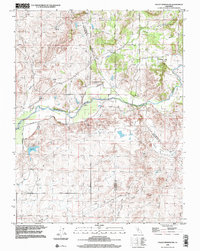
1998 Map of Valley Springs SW
USGS Topo · Published 2002About this map
The Calaveras River winds through this central California landscape at the convergence of San Joaquin, Calaveras, and Stanislaus counties. This late twentieth-century survey shows a region defined by agricultural history and mining legacy, with numerous areas of Tailings and an unnamed Mine situated near the Mother Lode Acres development. Family-named outposts like Stone Corral Ranch and Capital Ranch are situated near seasonal waterways such as Duck Creek and Indian Creek. Infrastructure including Airstrips and Flood Road reflect modern land use, yet the presence of an Old Railroad Grade and a lonely Cemetery east of Duck Creek provide tangible links to the area's older settlement patterns. Higher ground is marked by summits like Opal Hill and Bunker Hill, overlooking the various spillways and secondary routes like Shelton Road.
Find a feature on this map
28 named features on this map. Tap any name to fly to it.
Don’t see what you’re looking for? This feature index may not catch every label — zoom into the map to look around manually.
Map Details
Editions of this 1998 Valley Springs SW Map
This is the sole edition of this map. No revisions or reprints were ever made.
Other maps of this area

1889 · Jackson
USGS Topo · 1:125,000

1892 · Jackson
USGS Topo · 1:125,000

1894 · Lodi
USGS Topo · 1:125,000

1897 · Jackson
USGS Topo · 1:125,000

1902 · Jackson
USGS Topo · 1:125,000

1908 · Linden
USGS Topo · 1:31,680

1909 · Clements
USGS Topo · 1:31,680

1915 · Trigo
USGS Topo · 1:31,680

1915 · Peters
USGS Topo · 1:31,680

1916 · Bachelor Valley
USGS Topo · 1:31,680