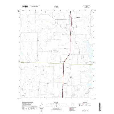
2019 Map of Valley View
USGS Topo · Published 2019About this map
Sanger and Valley View anchor this North Texas corridor, illustrating the modern landscape at the Cooke and Denton County line. The terrain is defined by a dense network of seasonal drainages, including Pecan Creek and Duck Creek, which flow through the rolling prairie. Notable aviation landmarks like Horseshoe Lake Airport and the Bar V K Airport highlight the region's private airfield infrastructure. Central to the area's geography is the BNSF Railway, which runs parallel to the major highway system, maintaining the historical transport spine that originally established these North Texas towns. The map also records smaller crossroads like Lois and localized geographic features such as Fossil Ridge, showing how modern residential development and agriculture sit alongside established rural landmarks.
Find a feature on this map
105 named features on this map. Tap any name to fly to it.
Don’t see what you’re looking for? This feature index may not catch every label — zoom into the map to look around manually.
Map Details
Editions of this 2019 Valley View Map
This is the sole edition of this map. No revisions or reprints were ever made.
Other maps of this area

1902 · Gainesville
USGS Topo · 1:125,000

1943 · Gainesville
USGS Topo · 1:125,000

1954 · Sherman
USGS Topo · 1:250,000

1958 · Sherman
USGS Topo · 1:250,000

1960 · Sanger
USGS Topo · 1:24,000

1960 · Green Valley
USGS Topo · 1:24,000

1960 · Gainesville South
USGS Topo · 1:24,000

1960 · Woodbine
USGS Topo · 1:24,000

1961 · Era
USGS Topo · 1:24,000
1961 · Era SE
USGS Topo · 1:24,000