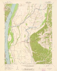
1954 Map of Valmeyer
USGS Topo · Published 1959About this map
Valmeyer and its surrounding river bottoms are defined here by a complex system of levees protecting agricultural land from the shifting Mississippi River. In the mid-1950s, the Missouri Pacific railroad serves as a critical corridor through the valley, passing near settlements like Fountain and Harrisonville. The landscape transitions abruptly from the low-lying floodplain near Meissner Island to the higher bluffs of the Illinois side, where hollows such as Dennis Hollow and Trout Hollow cut through the rising terrain.
Find a feature on this map
36 named features on this map. Tap any name to fly to it.
Don’t see what you’re looking for? This feature index may not catch every label — zoom into the map to look around manually.
Map Details
Editions of this 1954 Valmeyer Map
4 editions found
Other maps of this area

1910 · Waterloo
USGS Topo · 1:62,500

1912 · Kimmswick
USGS Topo · 1:62,500

1913 · Waterloo
USGS Topo · 1:62,500

1915 · Renault
USGS Topo · 1:62,500

1915 · Crystal City
USGS Topo · 1:62,500

1916 · Kimmswick
USGS Topo · 1:62,500

1940 · Renault
USGS Topo · 1:62,500

1948 · Kimmswick
USGS Topo · 1:62,500

1949 · Saint Louis
USGS Topo · 1:250,000

1949 · Crystal City
USGS Topo · 1:62,500