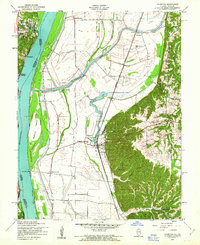
1954 Map of Valmeyer
USGS Topo · Published 1969About this map
Valmeyer and the rich alluvial bottomlands of the American Bottom define this mid-century landscape along the Mississippi River. The map illustrates a complex relationship between the river and the residents of Monroe County, evidenced by the extensive Levee systems protecting agricultural tracts and small communities. Transport and trade are anchored by the Missouri Pacific railroad, which runs parallel to the bluffs through Fountain and past the distinctive Moredock Lake.
Find a feature on this map
36 named features on this map. Tap any name to fly to it.
Don’t see what you’re looking for? This feature index may not catch every label — zoom into the map to look around manually.
Map Details
Editions of this 1954 Valmeyer Map
4 editions found
Other maps of this area

1910 · Waterloo
USGS Topo · 1:62,500

1912 · Kimmswick
USGS Topo · 1:62,500

1913 · Waterloo
USGS Topo · 1:62,500

1915 · Renault
USGS Topo · 1:62,500

1915 · Crystal City
USGS Topo · 1:62,500

1916 · Kimmswick
USGS Topo · 1:62,500

1940 · Renault
USGS Topo · 1:62,500

1948 · Kimmswick
USGS Topo · 1:62,500

1949 · Saint Louis
USGS Topo · 1:250,000

1949 · Crystal City
USGS Topo · 1:62,500