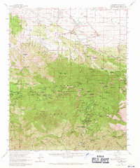
1959 Map of Valyermo
USGS Topo · Published 1971About this map
St Andrews Priory sits at the northern base of the high peaks, marking a transition between the arid Antelope Valley and the dense forests of the Angelles National Forest. This 1950s survey captures the era when the Crystal Lake Recreation Area and its surrounding Crystal Lake Country Club were primary mountain retreats for Southern California. The map details a landscape defined by significant elevation changes, from the alluvial fans of Valyermo and Juniper Hills to the nearly 10,000-foot summit of Mt Baden-Powell. Evidence of early industrial and agricultural activity is preserved through labels for the Bobs Gap Limekiln and various homesteads like McFarland Ranch and Mile High Ranch. The complex drainage patterns of Big Rock Creek and the San Gabriel River highlight the vital water sources that shaped settlement along the desert's edge.
Find a feature on this map
64 named features on this map. Tap any name to fly to it.
Don’t see what you’re looking for? This feature index may not catch every label — zoom into the map to look around manually.
Map Details
Editions of this 1959 Valyermo Map
2 editions found
Other maps of this area

1894 · Los Angeles
USGS Topo · 1:62,500

1894 · Pomona
USGS Topo · 1:62,500

1896 · Pasadena
USGS Topo · 1:62,500

1897 · Pomona
USGS Topo · 1:62,500

1897 · Cucamonga
USGS Topo · 1:62,500

1898 · Pomona
USGS Topo · 1:62,500

1900 · Pasadena
USGS Topo · 1:62,500

1900 · Tujunga
USGS Topo · 1:62,500

1900 · Los Angeles
USGS Topo · 1:62,500

1900 · Cucamonga
USGS Topo · 1:62,500