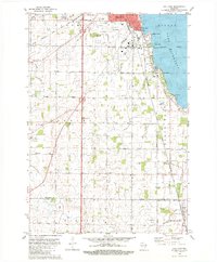
1980 Map of Van Dyne
USGS Topo · Published 1981About this map
Lake Winnebago shapes the eastern landscape of this 1980 survey, where the urban fringe of Oshkosh transitions into the fertile township of Nekimi. The shoreline is dotted with established lakefront communities like Stony Beach, Roe Point, and Paukotuk, while the interior preserves a dense network of family-held farms and rural institutions. The transportation corridor is anchored by the Chicago And North Western railroad and the expansive grounds of Wittman Field.
Find a feature on this map
62 named features on this map. Tap any name to fly to it.
Don’t see what you’re looking for? This feature index may not catch every label — zoom into the map to look around manually.
Map Details
Editions of this 1980 Van Dyne Map
This is the sole edition of this map. No revisions or reprints were ever made.
Other maps of this area

1910 · Fond du Lac
USGS Topo · 1:62,500

1911 · Neenah
USGS Topo · 1:62,500

1955 · Neenah
USGS Topo · 1:62,500

1955 · Fond Du Lac
USGS Topo · 1:62,500

1955 · Fond Du Lac
USGS Topo · 1:24,000

1955 · Green Bay
USGS Topo · 1:250,000

1956 · Rosendale
USGS Topo · 1:62,500

1957 · Madison
USGS Topo · 1:250,000

1960 · Madison
USGS Topo · 1:250,000

1961 · Oshkosh
USGS Topo · 1:24,000