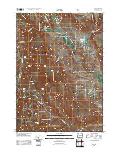
2011 Map of Van
USGS Topo · Published 2011About this map
Cleveland Ranch and the small settlement of Van sit at the northern edge of this high-desert landscape in Harney County, where the high-altitude water network dictates the layout of human activity. The map reveals a remote ranching economy centered around water sources like Duck Creek Reservoir and numerous named springs, including the descriptively titled Little Briches Spring, Skookum Spring, and Fourth of July Spring. The terrain is shaped by Capps Mountain and drained by a complex system of creeks such as Gunbarrel Creek, Calamity Creek, and Muddy Creek. Access is maintained through a network of rural routes including Van-Drewsey Rd and Calamity Creek Rd, connecting isolated landmarks like the Jack Bear Cabin and Jones Ranch to the larger region.
Find a feature on this map
35 named features on this map. Tap any name to fly to it.
Don’t see what you’re looking for? This feature index may not catch every label — zoom into the map to look around manually.
Map Details
Editions of this 2011 Van Map
This is the sole edition of this map. No revisions or reprints were ever made.
Other maps of this area

1955 · Burns
USGS Topo · 1:250,000

1955 · Canyon City
USGS Topo · 1:250,000

1958 · Burns
USGS Topo · 1:250,000

1959 · Burns
USGS Topo · 1:250,000

1959 · Canyon City
USGS Topo · 1:250,000

1961 · Calamity Butte
USGS Topo · 1:62,500

1961 · Logan Valley
USGS Topo · 1:62,500

1961 · Seneca
USGS Topo · 1:62,500

1968 · Van
USGS Topo · 1:62,500

1978 · John Day
USGS Topo · 1:100,000