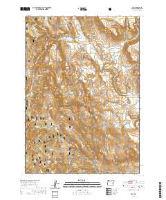
2020 Map of Van
USGS Topo · Published 2020About this map
The small settlement of Van and the high point of Capps Mtn anchor this high-desert landscape in Harney County. The area is defined by its water management and grazing history, evidenced by Cleveland Ditch and the expansive reaches of the Malheur National Forest. This terrain is remarkably rich in named water sources, vital for ranching and survival in the Oregon interior. Named springs like Diamond Spring, Skookum Spring, and Little Britches Spring dot the landscape near Potts Field. Modern roads like the Van-Drewsey Rd and Calamity Creek Rd follow natural drainage paths through the ridges, tracing a long history of movement between isolated ranching outposts and more established settlements to the south. The presence of McEwen Spring and Muller Basin Spring suggest family-named landmarks that are essential for genealogists tracing ancestors in the high Oregon rangeland.
Find a feature on this map
32 named features on this map. Tap any name to fly to it.
Don’t see what you’re looking for? This feature index may not catch every label — zoom into the map to look around manually.
Map Details
Editions of this 2020 Van Map
This is the sole edition of this map. No revisions or reprints were ever made.
Other maps of this area
1955 · Burns
USGS Topo · 1:250,000
1955 · Canyon City
USGS Topo · 1:250,000
1958 · Burns
USGS Topo · 1:250,000
1959 · Burns
USGS Topo · 1:250,000
1959 · Canyon City
USGS Topo · 1:250,000
1961 · Calamity Butte
USGS Topo · 1:62,500
1961 · Logan Valley
USGS Topo · 1:62,500
1961 · Seneca
USGS Topo · 1:62,500
1968 · Van
USGS Topo · 1:62,500
1978 · John Day
USGS Topo · 1:100,000