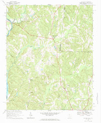
1968 Map of Van Wyck
USGS Topo · Published 1984About this map
The Catawba River defines the western edge of this landscape, where the Seaboard Coast Line and Southern railroads once navigated the rolling terrain of Lancaster County. At the heart of the region, Andrew Jackson State Park surrounds the Andrew Jackson Memorial, marking the local history of the seventh president. The settlement pattern is largely rural, anchored by crossroads communities like Fosters Crossroads and Van Wyck.
Find a feature on this map
51 named features on this map. Tap any name to fly to it.
Don’t see what you’re looking for? This feature index may not catch every label — zoom into the map to look around manually.
Map Details
Editions of this 1968 Van Wyck Map
2 editions found
Other maps of this area

1941 · Spartanburg
USGS Topo · 1:250,000

1953 · Spartanburg
USGS Topo · 1:250,000

1960 · Spartanburg
USGS Topo · 1:250,000

1963 · Spartanburg
USGS Topo · 1:250,000

1964 · Spartanburg
USGS Topo · 1:250,000

1968 · Van Wyck
USGS Topo · 1:24,000

1968 · Catawba
USGS Topo · 1:24,000
1968 · Catawba NE
USGS Topo · 1:24,000
1968 · Rock Hill East
USGS Topo · 1:24,000

1969 · Antioch
USGS Topo · 1:24,000