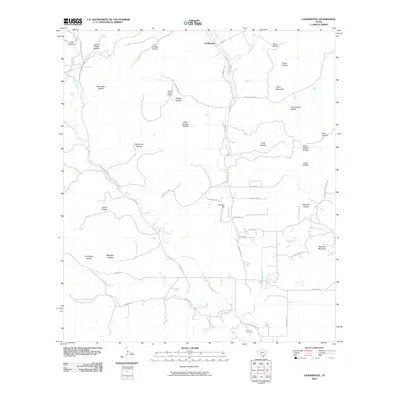
2010 Map of Vanderpool
USGS Topo · Published 2010About this map
The Sabinal River and its western fork dominate this portion of Bandera County, carving a series of dramatic drainages through the limestone geography. The small community of Vanderpool serves as the local anchor at the junction of Ranch Rd 187 and Ranch Rd 337. The landscape is defined by dozens of named canyons and hollows, such as Starvation Hollow and Jim Jernigan Hollow, which speak to the area's pioneer history and the challenges of early settlement. Significant topographical markers include Taylor Mountain and Wernette Mountain, while the presence of the Foster Ranch Airport and various ranch roads like Foster Ranch Rd and Encino Ranch Rd indicate the modern transition of these large family holdings. In the south, the Jones Cemetery remains a vital record of the families who established the cattle and goat ranching traditions of the Texas Hill Country.
Find a feature on this map
52 named features on this map. Tap any name to fly to it.
Don’t see what you’re looking for? This feature index may not catch every label — zoom into the map to look around manually.
Map Details
Editions of this 2010 Vanderpool Map
This is the sole edition of this map. No revisions or reprints were ever made.
Other maps of this area

1954 · San Antonio
USGS Topo · 1:250,000

1956 · Tarpley
USGS Topo · 1:62,500

1956 · Tuff
USGS Topo · 1:62,500

1956 · Utopia
USGS Topo · 1:62,500

1957 · San Antonio
USGS Topo · 1:250,000

1960 · Magers Crossing
USGS Topo · 1:24,000

1964 · Circle Bluff
USGS Topo · 1:24,000

1964 · Sabinal Canyon
USGS Topo · 1:24,000
1964 · Love Creek
USGS Topo · 1:24,000
1964 · Seco Pass
USGS Topo · 1:24,000