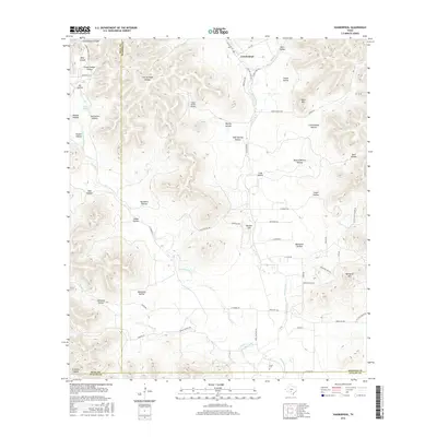
2016 Map of Vanderpool
USGS Topo · Published 2016About this map
The Sabinal River and its western fork, the W Sabinal River, carve through the complex drainage systems of Bandera, Real, and Uvalde counties. This 2016 survey shows the community of Vanderpool situated where Ranch Rd 187 meets Ranch Rd 337, serving as a central point in a landscape defined by named hollows and canyons. Genealogists and local historians will find several family-named landmarks such as Taylor Mtn, Wernette Mtn, and Foster Hollow. The presence of the Jones Cem and the Foster Ranch Airport along the river valleys illustrates the blend of traditional ranching heritage and modern accessibility. The map's detail extends to numerous small canyons like Bear Canyon and Cottonwood Canyon, alongside specialized locations such as Camp Fiddler Hollow and Starvation Hollow, reflecting the unique nomenclature of the Texas Hill Country.
Find a feature on this map
65 named features on this map. Tap any name to fly to it.
Don’t see what you’re looking for? This feature index may not catch every label — zoom into the map to look around manually.
Map Details
Editions of this 2016 Vanderpool Map
This is the sole edition of this map. No revisions or reprints were ever made.
Other maps of this area

1954 · San Antonio
USGS Topo · 1:250,000

1956 · Tarpley
USGS Topo · 1:62,500

1956 · Tuff
USGS Topo · 1:62,500

1956 · Utopia
USGS Topo · 1:62,500

1957 · San Antonio
USGS Topo · 1:250,000

1960 · Magers Crossing
USGS Topo · 1:24,000

1964 · Circle Bluff
USGS Topo · 1:24,000

1964 · Sabinal Canyon
USGS Topo · 1:24,000
1964 · Love Creek
USGS Topo · 1:24,000
1964 · Seco Pass
USGS Topo · 1:24,000