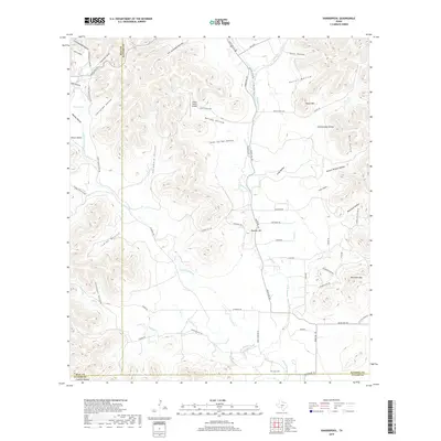
2019 Map of Vanderpool
USGS Topo · Published 2019About this map
The Sabinal River and its western fork, the W Sabinal River, carve through this section of the Texas Hill Country near the intersection of Bandera, Real, and Uvalde counties. The landscape is defined by a dense network of drainages and named valleys, including Starvation Hollow, Cottonwood Hollow, and Jim Jernigan Hollow. These features reflect a rugged terrain where water management and ranching have long dictated the patterns of settlement and movement.
Find a feature on this map
64 named features on this map. Tap any name to fly to it.
Don’t see what you’re looking for? This feature index may not catch every label — zoom into the map to look around manually.
Map Details
Editions of this 2019 Vanderpool Map
This is the sole edition of this map. No revisions or reprints were ever made.
Other maps of this area

1954 · San Antonio
USGS Topo · 1:250,000

1956 · Tarpley
USGS Topo · 1:62,500

1956 · Tuff
USGS Topo · 1:62,500

1956 · Utopia
USGS Topo · 1:62,500

1957 · San Antonio
USGS Topo · 1:250,000

1960 · Magers Crossing
USGS Topo · 1:24,000

1964 · Circle Bluff
USGS Topo · 1:24,000

1964 · Sabinal Canyon
USGS Topo · 1:24,000
1964 · Love Creek
USGS Topo · 1:24,000
1964 · Seco Pass
USGS Topo · 1:24,000