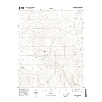
2017 Map of Vanderwagen Draw
USGS Topo · Published 2017About this map
Vanderwagen Draw defines this landscape in the Eastern Navajo Agency, where seasonal drainage patterns have carved a network of washes and canyons through the high-elevation terrain. This 2017 survey shows a region largely characterized by its natural features, with Dubois Hill and White Canyon serving as prominent landmarks among the township and range divisions. The area's limited infrastructure consists of a few specialized roads such as Stonehedge Rd, Blue Ray Rd, and Indian Svc Rte 11, reflecting a remote and sparsely developed character. The hydrology of the region is centered on Bosson Wash and Oak Wash, which channel water through the high desert during the monsoon season. This map provides a clear record of the modern rural road network and the topographical features that dictate the movement of water and travel across this corner of New Mexico.
Find a feature on this map
26 named features on this map. Tap any name to fly to it.
Don’t see what you’re looking for? This feature index may not catch every label — zoom into the map to look around manually.
Map Details
Editions of this 2017 Vanderwagen Draw Map
This is the sole edition of this map. No revisions or reprints were ever made.
Other maps of this area

1886 · Wingate
USGS Topo · 1:250,000

1892 · Wingate
USGS Topo · 1:250,000

1954 · Gallup
USGS Topo · 1:250,000

1958 · Gallup
USGS Topo · 1:250,000

1959 · Gallup
USGS Topo · 1:250,000

1962 · Gallup
USGS Topo · 1:250,000

1963 · Jones Ranch School
USGS Topo · 1:24,000

1963 · Pinehaven
USGS Topo · 1:24,000
1963 · Vander Wagen
USGS Topo · 1:24,000

1967 · Gallup
USGS Topo · 1:250,000