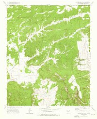
1972 Map of Vanderwagen Draw
USGS Topo · Published 1976About this map
The Zuni Indian Reservation dominates this landscape in McKinley County, defined by a network of seasonal watercourses and high-elevation terrain. Surveyed in the early 1970s, the map illustrates a sparsely populated region where infrastructure is limited to isolated points like Cousins and a Radio Tower in the northern sector. The complex drainage systems of Vanderwagen Draw, Bosson Wash, and Oak Wash weave through the topography, reflecting the hydrologic patterns of the high desert.
Find a feature on this map
20 named features on this map. Tap any name to fly to it.
Don’t see what you’re looking for? This feature index may not catch every label — zoom into the map to look around manually.
Map Details
Editions of this 1972 Vanderwagen Draw Map
This is the sole edition of this map. No revisions or reprints were ever made.
Other maps of this area

1886 · Wingate
USGS Topo · 1:250,000

1892 · Wingate
USGS Topo · 1:250,000

1954 · Gallup
USGS Topo · 1:250,000

1958 · Gallup
USGS Topo · 1:250,000

1959 · Gallup
USGS Topo · 1:250,000

1962 · Gallup
USGS Topo · 1:250,000

1963 · Jones Ranch School
USGS Topo · 1:24,000

1963 · Pinehaven
USGS Topo · 1:24,000
1963 · Vander Wagen
USGS Topo · 1:24,000

1967 · Gallup
USGS Topo · 1:250,000