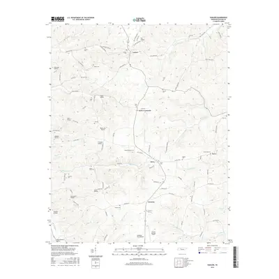
2016 Map of Vanleer
USGS Topo · Published 2016About this map
Vanleer and its surrounding rural communities in Dickson County appear in this 2016 survey, defined by a dense network of hollows and family-named cemeteries. The landscape is carved by numerous watercourses, including Sulphur Fork Cr and Furnace Cr, which snake through terrain dotted with landmarks like Black John Hollow and Plum Orchard Hollow. This region shows a remarkably preserved pattern of localized family history, where names on the roads often match the nearby burial grounds, such as Taylor Cem near Taylor Crossroads and Sylvia Cem in Sylvia. In the southern portion of the map, the Dickson Municipal Airport sits on higher ground above Standing Rock Hollow, illustrating the modern infrastructure integrated into this traditionally agricultural landscape. For genealogists, the map is a primary source for locating smaller, tucked-away sites like Baggett Cem and Fraudenthal Cem that are often missed in broader surveys.
Find a feature on this map
102 named features on this map. Tap any name to fly to it.
Don’t see what you’re looking for? This feature index may not catch every label — zoom into the map to look around manually.
Map Details
Editions of this 2016 Vanleer Map
This is the sole edition of this map. No revisions or reprints were ever made.
Other maps of this area

1931 · Erin
USGS Topo · 1:62,500

1936 · Ruskin
USGS Topo · 1:24,000

1936 · Burns
USGS Topo · 1:24,000

1936 · Tennessee City
USGS Topo · 1:24,000

1936 · Dickson
USGS Topo · 1:24,000

1953 · Dickson
USGS Topo · 1:24,000
1953 · Tennessee City
USGS Topo · 1:24,000

1953 · Burns
USGS Topo · 1:24,000
1953 · Ruskin
USGS Topo · 1:24,000

1956 · Nashville
USGS Topo · 1:250,000