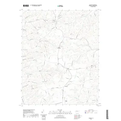
2019 Map of Vanleer
USGS Topo · Published 2019About this map
Vanleer serves as the primary hub in this portion of Dickson County, situated at the intersection of local routes in a landscape defined by deeply incised drainages and high ridges. The area's settlement pattern is closely tied to its terrain, with numerous small communities like Taylor Crossroads, Sylvia, and Hortense linked by winding roads that follow the contours of the land. The map reveals an extensive genealogical record through its many family and community burial grounds, including Fraudenthal Cem, Maple Grove Cem, and Antioch Cem. Waterways such as Bear Cr, E Fork Yellow Cr, and Sulphur Fork Cr have carved out named landforms like Newman Hollow and Logans Hollow, which shaped the early development of this rural Tennessee region. To the south, the Dickson Municipal Airport stands as a more modern landmark in an otherwise largely agricultural and wooded territory.
Find a feature on this map
110 named features on this map. Tap any name to fly to it.
Don’t see what you’re looking for? This feature index may not catch every label — zoom into the map to look around manually.
Map Details
Editions of this 2019 Vanleer Map
This is the sole edition of this map. No revisions or reprints were ever made.
Other maps of this area

1931 · Erin
USGS Topo · 1:62,500

1936 · Ruskin
USGS Topo · 1:24,000

1936 · Burns
USGS Topo · 1:24,000

1936 · Tennessee City
USGS Topo · 1:24,000

1936 · Dickson
USGS Topo · 1:24,000

1953 · Dickson
USGS Topo · 1:24,000
1953 · Tennessee City
USGS Topo · 1:24,000

1953 · Burns
USGS Topo · 1:24,000
1953 · Ruskin
USGS Topo · 1:24,000

1956 · Nashville
USGS Topo · 1:250,000