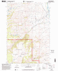
1997 Map of Varney
USGS Topo · Published 2002About this map
Madison River valley life and high-altitude water management define this late-20th-century survey of the Gravelly Range foothills. Near the small settlement of Varney, the river’s importance to local industry and conservation is evident through the presence of the Ennis National Fish Hatchery and irrigation infrastructure like the Shewmaker Ditch. The map illustrates the transition from the riparian lowlands to the protected highlands of the Beaverhead National Forest, where smaller water bodies such as Axolotl Lakes and Haypress Lakes dot the landscape.
Find a feature on this map
31 named features on this map. Tap any name to fly to it.
Don’t see what you’re looking for? This feature index may not catch every label — zoom into the map to look around manually.
Map Details
Editions of this 1997 Varney Map
This is the sole edition of this map. No revisions or reprints were ever made.
Other maps of this area

1888 · Three Forks
USGS Topo · 1:250,000

1894 · Three Forks
USGS Topo · 1:250,000

1895 · Three Forks
USGS Topo · 1:250,000

1947 · Bozeman
USGS Topo · 1:250,000

1948 · Bozeman
USGS Topo · 1:250,000

1949 · Varney
USGS Topo · 1:62,500

1949 · Ennis
USGS Topo · 1:62,500

1950 · Cameron
USGS Topo · 1:62,500

1950 · Virginia City
USGS Topo · 1:62,500

1955 · Bozeman
USGS Topo · 1:250,000