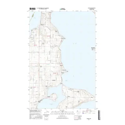
2017 Map of Vashon
USGS Topo · Published 2017About this map
Vashon and its surrounding island communities are intricately detailed in this 2017 survey, showing the residential and agricultural layout of this prominent Puget Sound landmark. The map traces the island's unique geography, from the northern reach of Cowley down to the narrow connection at Portage that joins the main island to Maury Island. Long-established settlements such as Burton, Ellisport, and Chautauqua are visible along the eastern shoreline, while the western side faces the Colvos Passage. Small-scale aviation and local infrastructure are represented by the Vashon Municipal Airport and Wax Orchards Airport. Interior water features like Judd Creek and Frenchmans Pond provide insight into the island's drainage patterns, while coastal labels like Magnolia Beach and Mileta pinpoint historic waterfront neighborhoods. The dense network of island roads, such as Vashon Heights Road, illustrates the modern connectivity of these isolated landmasses.
Find a feature on this map
87 named features on this map. Tap any name to fly to it.
Don’t see what you’re looking for? This feature index may not catch every label — zoom into the map to look around manually.
Map Details
Editions of this 2017 Vashon Map
This is the sole edition of this map. No revisions or reprints were ever made.
Other maps of this area

1894 · Seattle
USGS Topo · 1:62,500

1895 · Snohomish
USGS Topo · 1:125,000

1897 · Tacoma
USGS Topo · 1:125,000

1897 · Seattle
USGS Topo · 1:125,000

1900 · Tacoma
USGS Topo · 1:125,000

1908 · Seattle
USGS Topo · 1:62,500

1909 · Seattle Special
USGS Topo · 1:62,500

1937 · Port Orchard
USGS Topo · 1:62,500

1942 · Gig Harbor
USGS Topo · 1:62,500

1943 · Gig Harbor
USGS Topo · 1:62,500