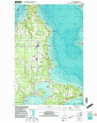
1997 Map of Vashon
USGS Topo · Published 2003About this map
Vashon Island and Maury Island define this coastal landscape in the late 1990s, separated by the deep indentation of Quartermaster Harbor. The island is a patchwork of small residential clusters and wooded tracts, with the primary hub at Vashon and a secondary center at Burton. The map reveals a dense network of local roads such as SW Cove Road and SW Bank Road that connect isolated beaches like Sylvan Beach and Magnolia Beach. Cultural and civic infrastructure is well-established, evidenced by the Vashon Municipal Airport, Vashon Island High Sch, and several community parks. This survey offers a clear view of the island's transition from a collection of rural homesteads and beach colonies to a more integrated residential community. Noteworthy sites like Camp Burton and the former Aquarium (Site) near Cowley point to the island's long-standing role as a recreational and institutional refuge within the Puget Sound.
Find a feature on this map
65 named features on this map. Tap any name to fly to it.
Don’t see what you’re looking for? This feature index may not catch every label — zoom into the map to look around manually.
Map Details
Editions of this 1997 Vashon Map
This is the sole edition of this map. No revisions or reprints were ever made.
Other maps of this area

1894 · Seattle
USGS Topo · 1:62,500

1895 · Snohomish
USGS Topo · 1:125,000

1897 · Tacoma
USGS Topo · 1:125,000

1897 · Seattle
USGS Topo · 1:125,000

1900 · Tacoma
USGS Topo · 1:125,000

1908 · Seattle
USGS Topo · 1:62,500

1909 · Seattle Special
USGS Topo · 1:62,500

1937 · Port Orchard
USGS Topo · 1:62,500

1942 · Gig Harbor
USGS Topo · 1:62,500

1943 · Gig Harbor
USGS Topo · 1:62,500