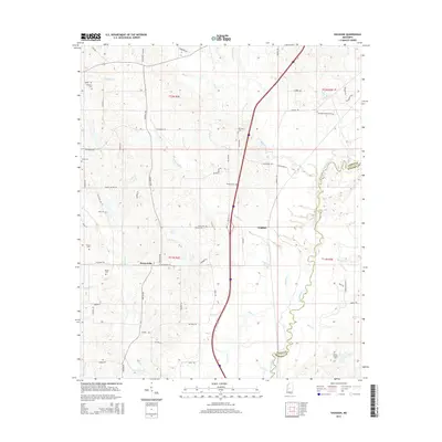
2015 Map of Vaughan
USGS Topo · Published 2015About this map
The Big Black River forms a natural boundary between Yazoo and Madison counties in this central Mississippi landscape. The settlement of Vaughan sits near the center of the map, serving as a focal point for the surrounding rural territory, while the community of Deasonville is located further west along Vaughan Rd. This area is characterized by an extensive network of creeks, including Vaughan Cr, Lock Cr, and Big Cypress Cr, which drain the varied terrain. Numerous family and community cemeteries are scattered throughout the region, such as the Strangers Home Cem, Peaster Cem, and the Tucker Family Cem. These sites, along with established roads like Butler Rd and Upshaw Rd, suggest a long-standing pattern of rural habitation and family-centered landownership that has persisted into the 21st century.
Find a feature on this map
64 named features on this map. Tap any name to fly to it.
Don’t see what you’re looking for? This feature index may not catch every label — zoom into the map to look around manually.
Map Details
Editions of this 2015 Vaughan Map
This is the sole edition of this map. No revisions or reprints were ever made.
Other maps of this area

1953 · Meridian
USGS Topo · 1:250,000

1955 · Jackson
USGS Topo · 1:250,000

1957 · Meridian
USGS Topo · 1:250,000

1960 · Sharon
USGS Topo · 1:62,500

1961 · Jackson
USGS Topo · 1:250,000

1961 · Canton
USGS Topo · 1:62,500

1962 · Jackson
USGS Topo · 1:250,000
1964 · Zeiglerville
USGS Topo · 1:24,000
1964 · Ebenezer
USGS Topo · 1:24,000

1964 · Linwood
USGS Topo · 1:24,000