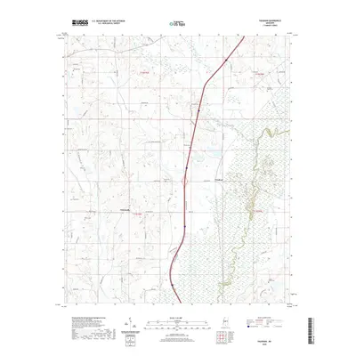
2020 Map of Vaughan
USGS Topo · Published 2020About this map
Vaughan and Deasonville anchor this Yazoo County landscape where the Big Black River forms a winding southern boundary with Madison County. The map reveals a high concentration of burial grounds, providing significant value for genealogists tracking family names through landmarks like Tucker Family Cem, Strangers Home Cem, and Peaster Cem. The terrain is defined by a dense network of drainage, including Big Cypress Cr, Ellison Cr, and Vaughan Cr, which flow through the lowland basins between local ridges. A distinct rural road network, including the historic routes of Vaughan Rd and McCullough Rd, connects these scattered settlements and cemeteries to the larger river system. The presence of Blanden Spr in the northeast corner further illustrates the importance of natural water sources to the area's development and historical settlement patterns.
Find a feature on this map
62 named features on this map. Tap any name to fly to it.
Don’t see what you’re looking for? This feature index may not catch every label — zoom into the map to look around manually.
Map Details
Editions of this 2020 Vaughan Map
This is the sole edition of this map. No revisions or reprints were ever made.
Other maps of this area

1953 · Meridian
USGS Topo · 1:250,000

1955 · Jackson
USGS Topo · 1:250,000

1957 · Meridian
USGS Topo · 1:250,000

1960 · Sharon
USGS Topo · 1:62,500

1961 · Jackson
USGS Topo · 1:250,000

1961 · Canton
USGS Topo · 1:62,500

1962 · Jackson
USGS Topo · 1:250,000
1964 · Zeiglerville
USGS Topo · 1:24,000
1964 · Ebenezer
USGS Topo · 1:24,000

1964 · Linwood
USGS Topo · 1:24,000