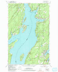
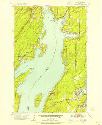
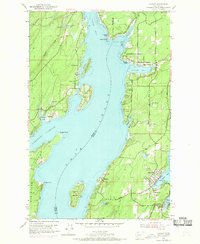
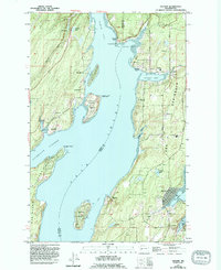
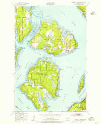
1953 Map of Vaughn
USGS Topo · Published 1991About this map
The waters of Case Inlet divide this South Puget Sound landscape, separating the Key Peninsula in Pierce County from the eastern shores of Mason County. This mid-century survey documents a maritime-oriented settlement pattern where small communities like Lakebay, Home, and Grapeview are anchored by protected coves and inlets. The presence of the Grapeview Sch and Lakebay Sch alongside local landmarks like Sunshine Beach and Olympic Shore reflects a period of established residential growth and recreation along the shorelines. On the Mason County side, Stretch Island and Reach Island sit tucked into Pickering Passage, with Stretch Point State Park marking the southern tip of the island. The map also captures the early road network that defined movement through the timbered uplands, including Wright Bliss Road and Gig Harbor-Longbranch Road, connecting the inland farms to the coastal docks and landings.
Find a feature on this map
47 named features on this map. Tap any name to fly to it.
Don’t see what you’re looking for? This feature index may not catch every label — zoom into the map to look around manually.
Map Details
Editions of this 1953 Vaughn Map
4 editions found
Other maps of this area

1937 · Olympia
USGS Topo · 1:62,500

1938 · Allyn
USGS Topo · 1:62,500

1940 · Anderson Island
USGS Topo · 1:62,500

1942 · Gig Harbor
USGS Topo · 1:62,500

1943 · Gig Harbor
USGS Topo · 1:62,500

1948 · Anderson Island
USGS Topo · 1:62,500
1948 · Anderson Island
USGS Topo · 1:24,000

1949 · Olympia
USGS Topo · 1:62,500
1953 · Burley
USGS Topo · 1:24,000
1953 · Sylvan
USGS Topo · 1:24,000