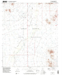
1996 Map of Vaya Chin
USGS Topo · Published 2001About this map
Vaya Chin serves as a central point of reference in this arid region of the Tohono O'odham Indian Reservation during the late 1990s. The landscape is defined by the broad Quijotoa Valley, a desert expanse where water management is critical for survival and land use, as evidenced by several remote outposts like Window Mountain Well and various unnamed wells and a Water Tank. The drainage of San Simon Wash cuts across the basin, oriented between the high elevations of the Castle Mountains to the north and the Sierra Blanca to the southeast. A small Cem near the settlement and scattered corrals indicate a continued pattern of small-scale ranching and community life within the reservation boundaries. This period of mapping follows the Gila and Salt River Meridian, highlighting how colonial survey grids were overlaid upon ancestral lands.
Find a feature on this map
13 named features on this map. Tap any name to fly to it.
Don’t see what you’re looking for? This feature index may not catch every label — zoom into the map to look around manually.
Map Details
Editions of this 1996 Vaya Chin Map
This is the sole edition of this map. No revisions or reprints were ever made.
Other maps of this area

1953 · Ajo
USGS Topo · 1:250,000

1957 · Ajo
USGS Topo · 1:250,000

1958 · Ajo
USGS Topo · 1:250,000

1962 · Ajo
USGS Topo · 1:250,000

1963 · Ajo
USGS Topo · 1:250,000

1963 · Gu Achi
USGS Topo · 1:62,500

1963 · Quijotoa Mts
USGS Topo · 1:62,500

1963 · Cimarron Peak
USGS Topo · 1:62,500

1963 · Pisinimo
USGS Topo · 1:62,500

1967 · Ajo
USGS Topo · 1:250,000