
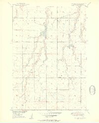
1950 Map of Vayland NW
USGS Topo · Published 1950About this map
Turtle Creek meanders through this portion of Hand County, defining a landscape of prairie drainage and small-scale rural infrastructure. This mid-century survey captures a pattern of isolated farmsteads and the critical role of local education in the Great Plains, evidenced by the distribution of one-room schools like Lone Star Sch, Lone Tree Sch, Corrin Sch, and Evans Sch. These structures, alongside the Town Hall, served as the primary civic anchors for the townships of Miller, St Lawrence, Logan, and Pearl. The terrain is punctuated by significant water features such as Jones Lake and Pearl Lake, which feed into the West Pearl and East Pearl Creek systems. A solitary Landing Field in the western section suggests the increasing importance of light aviation to these remote agricultural communities during the postwar era.
Find a feature on this map
15 named features on this map. Tap any name to fly to it.
Don’t see what you’re looking for? This feature index may not catch every label — zoom into the map to look around manually.
Map Details
Editions of this 1950 Vayland NW Map
2 editions found
Other maps of this area

1899 · Redfield
USGS Topo · 1:125,000

1949 · Vayland SE
USGS Topo · 1:24,000

1949 · Vayland SW
USGS Topo · 1:24,000

1950 · Ree Heights SE
USGS Topo · 1:24,000

1950 · Vayland
USGS Topo · 1:24,000

1951 · Vayland SW
USGS Topo · 1:24,000

1951 · Vayland SE
USGS Topo · 1:24,000

1953 · Huron
USGS Topo · 1:250,000

1954 · Huron
USGS Topo · 1:250,000

1967 · Miller
USGS Topo · 1:24,000