
1951 Map of Vayland SE
USGS Topo · Published 1951About this map
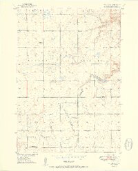
Rose Hill Ch and a series of rural schoolhouses define the social fabric of southeastern Hand County during the early 1950s. This agricultural landscape, mapped as part of the Department of the Interior's Missouri River Basin development program, is characterized by its dispersed community hubs, including Rowen Sch, Palmer Sch, Todd Sch, and Prairie View Sch. The area's hydrology is dominated by the winding course of Sand Creek, which feeds into Rose Hill Lake. Scattered infrastructure like a local Cem, a Gravel Pit, and various windmills indicate a self-sufficient prairie economy centered around the townships of Rose Hill, Spring Lake, and Bates. The topography, recorded using plane-table methods in 1949, reveals the subtle drainage patterns that dictated early settlement and land use in this part of South Dakota.
Find a feature on this map
17 named features on this map. Tap any name to fly to it.
Don’t see what you’re looking for? This feature index may not catch every label — zoom into the map to look around manually.
Map Details
Editions of this 1951 Vayland SE Map
2 editions found
Other maps of this area

1949 · Vayland SE
USGS Topo · 1:24,000

1949 · Vayland SW
USGS Topo · 1:24,000

1950 · Vayland
USGS Topo · 1:24,000

1950 · Wessington
USGS Topo · 1:24,000

1950 · Vayland NW
USGS Topo · 1:24,000

1951 · Vayland SW
USGS Topo · 1:24,000

1951 · Wessington SW
USGS Topo · 1:24,000

1953 · Huron
USGS Topo · 1:250,000

1954 · Huron
USGS Topo · 1:250,000

1973 · Cottonwood Lake
USGS Topo · 1:24,000