
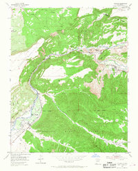
1953 Map of Velarde
USGS Topo · Published 1955About this map
The Rio Grande carves a deep valley through Northern New Mexico in the early 1950s, defining a landscape of traditional acequias and riverfront settlements. This survey captures the intricate irrigation network essential to the region, including the Low Ditch, Highway Ditch, and Plaza Ditch that sustain the valley floor. Clusters of community life are centered around Velarde, Dixon, and Embudo, where the Embudo Presbyterian Hospital and Embudo PO serve as local hubs.
Find a feature on this map
62 named features on this map. Tap any name to fly to it.
Don’t see what you’re looking for? This feature index may not catch every label — zoom into the map to look around manually.
Map Details
Editions of this 1953 Velarde Map
2 editions found
Other maps of this area

1918 · Abiquiu
USGS Topo · 1:125,000

1953 · San Juan Pueblo
USGS Topo · 1:24,000

1953 · Lyden
USGS Topo · 1:24,000

1953 · Truchas
USGS Topo · 1:24,000

1953 · Trampas
USGS Topo · 1:24,000

1953 · Chimayo
USGS Topo · 1:24,000

1953 · Ojo Caliente
USGS Topo · 1:24,000

1953 · San Juan Pueblo
USGS Topo · 1:62,500

1954 · Raton
USGS Topo · 1:250,000

1954 · Aztec
USGS Topo · 1:250,000