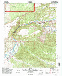
1995 Map of Velarde
USGS Topo · Published 1998About this map
The Rio Grande carves through the northern New Mexico landscape, shaping the development of tight-knit river communities like Velarde and Dixon. This 1995 revision reveals a complex layering of land ownership and history, dominated by the extensive Sebastian Martin Grant and Black Mesa Grant which define the local boundaries alongside the Carson National Forest. The infrastructure of the valley is evident in the irrigation systems and the Old Railroad Grade that runs parallel to the river, tracing the path of former commerce.
Find a feature on this map
37 named features on this map. Tap any name to fly to it.
Don’t see what you’re looking for? This feature index may not catch every label — zoom into the map to look around manually.
Map Details
Editions of this 1995 Velarde Map
This is the sole edition of this map. No revisions or reprints were ever made.
Other maps of this area

1918 · Abiquiu
USGS Topo · 1:125,000

1953 · San Juan Pueblo
USGS Topo · 1:24,000

1953 · Lyden
USGS Topo · 1:24,000

1953 · Truchas
USGS Topo · 1:24,000

1953 · Velarde
USGS Topo · 1:24,000

1953 · Trampas
USGS Topo · 1:24,000

1953 · Chimayo
USGS Topo · 1:24,000

1953 · Ojo Caliente
USGS Topo · 1:24,000

1953 · San Juan Pueblo
USGS Topo · 1:62,500

1954 · Raton
USGS Topo · 1:250,000