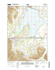
2014 Map of Veneta
USGS Topo · Published 2014About this map
Fern Ridge Lake dominates this portion of Lane County, with the rising waters of the mid-20th century defining the local geography around Richardson Point and Perkins Peninsula. The map details the growing communities of Veneta and Elmira, centers of settlement along the Territorial Hwy and Or-126. Away from the modern town centers, the landscape preserves older layers of residency, including the Richardson Cem and the Central Sch Association Cem. Smaller waterways like the Long Tom River and W Fork Coyote Cr thread through the southern hills and northern flats. Notable landforms such as Demming Ridge and Fisher Butte provide a topographical frame to the extensive wetlands and sloughs that feed into the lake, illustrating the complex drainage patterns of the southern Willamette Valley foothills.
Find a feature on this map
107 named features on this map. Tap any name to fly to it.
Don’t see what you’re looking for? This feature index may not catch every label — zoom into the map to look around manually.
Map Details
Editions of this 2014 Veneta Map
This is the sole edition of this map. No revisions or reprints were ever made.
Other maps of this area

1909 · Elmira
USGS Topo · 1:62,500

1910 · Eugene
USGS Topo · 1:62,500

1921 · Cottage Grove
USGS Topo · 1:62,500

1922 · Elmira
USGS Topo · 1:62,500

1940 · Eugene
USGS Topo · 1:62,500

1942 · Elmira
USGS Topo · 1:62,500

1942 · Crow
USGS Topo · 1:62,500

1945 · Crow
USGS Topo · 1:62,500

1946 · Eugene
USGS Topo · 1:62,500

1949 · Eugene
USGS Topo · 1:62,500