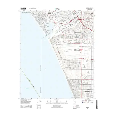
2015 Map of Venice
USGS Topo · Published 2015About this map
Santa Monica Mountains National Recreation Area meets the edge of the Pacific in this detailed coastal survey. The landscape is defined by the dense urban sprawl of west Los Angeles, stretching from the beachfront walks of Venice Beach and the massive marina complex at Marina del Rey to the inland heights of Baldwin Hills. The drainage of Ballona Creek and the Centinela Creek Channel provide a geographic break in the grid of major thoroughfares like Venice Blvd and W Manchester Ave. Notable institutional footprints include Loyola Marymount University and Otis College of Art and Design, while the sprawling grounds of Holy Cross Cemetery and Hillside Memorial Park stand out as significant green spaces. The southern portion of the map is dominated by the industrial and transport infrastructure of the Los Angeles International Airport and the coastal residential enclaves of El Segundo and Manhattan Beach.
Find a feature on this map
56 named features on this map. Tap any name to fly to it.
Don’t see what you’re looking for? This feature index may not catch every label — zoom into the map to look around manually.
Map Details
Editions of this 2015 Venice Map
This is the sole edition of this map. No revisions or reprints were ever made.
Other maps of this area

1894 · Los Angeles
USGS Topo · 1:62,500

1896 · Redondo
USGS Topo · 1:62,500

1896 · Santa Monica
USGS Topo · 1:62,500

1898 · Santa Monica
USGS Topo · 1:62,500

1900 · Los Angeles
USGS Topo · 1:62,500

1901 · Southern California Sheet No. 1
USGS Topo · 1:250,000

1902 · Santa Monica
USGS Topo · 1:62,500

1903 · Calabasas
USGS Topo · 1:62,500

1903 · Camulos
USGS Topo · 1:125,000

1904 · Southern California Sheet No. 1
USGS Topo · 1:250,000