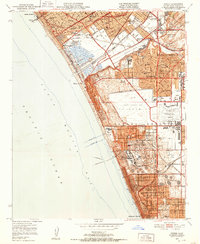
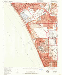
1950 Map of Venice
USGS Topo · Published 1952About this map
Los Angeles International Airport anchors this mid-century coastal study, shown during a period of massive transition as denoted by the large Airport Expansion Area pushing south toward El Segundo. The landscape is a dense grid of post-war development, featuring dozens of new educational institutions such as Westchester Jr HS, Westport Hts Sch, and Kentwood Sch. Oil infrastructure remains a visible part of the economy, with a large Refinery and numerous oil wells dotting the coastal bluffs. Transport corridors are well-defined by the Pacific Electric and Atchison Topeka and Santa Fe railroads, which parallel the coast and cut inland across Ballona Creek. From the canals of Venice to the growing neighborhoods of Manhattan Beach, the map captures the rapid suburbanization of the South Bay and the Westside.
Find a feature on this map
56 named features on this map. Tap any name to fly to it.
Don’t see what you’re looking for? This feature index may not catch every label — zoom into the map to look around manually.
Map Details
Editions of this 1950 Venice Map
2 editions found
Other maps of this area

1894 · Los Angeles
USGS Topo · 1:62,500

1896 · Redondo
USGS Topo · 1:62,500

1896 · Santa Monica
USGS Topo · 1:62,500

1898 · Santa Monica
USGS Topo · 1:62,500

1900 · Los Angeles
USGS Topo · 1:62,500

1901 · Southern California Sheet No. 1
USGS Topo · 1:250,000

1902 · Santa Monica
USGS Topo · 1:62,500

1903 · Calabasas
USGS Topo · 1:62,500

1903 · Camulos
USGS Topo · 1:125,000

1904 · Southern California Sheet No. 1
USGS Topo · 1:250,000