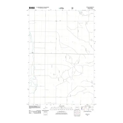
2011 Map of Venlo
USGS Topo · Published 2011About this map
The Sheyenne River winds through this North Dakota landscape, carving a prominent valley across the terrain. Located in Ransom County, the small settlement of Venlo sits along the northern edge of this grid-heavy rural area. The river's path is the most defining natural feature, creating a break in the uniform section lines that dominate the surrounding agriculture. A few key crossings and landmarks punctuate the landscape, notably Heaton Bridge on the western edge and the elevated terrain of Pigeon Point in the northeast corner. This map captures the intersection of the natural river corridor with the strict township-and-range road system, including routes like 64th St Se and 140th Ave Se. It reflects the 21st-century state of this rural prairie region, where land management and hydrography remain central to local geography.
Find a feature on this map
15 named features on this map. Tap any name to fly to it.
Don’t see what you’re looking for? This feature index may not catch every label — zoom into the map to look around manually.
Map Details
Editions of this 2011 Venlo Map
This is the sole edition of this map. No revisions or reprints were ever made.
Other maps of this area

1895 · Casselton
USGS Topo · 1:125,000

1897 · Tower
USGS Topo · 1:125,000

1897 · Casselton
USGS Topo · 1:125,000

1907 · Wyndmere
USGS Topo · 1:125,000

1953 · Fargo
USGS Topo · 1:250,000

1956 · Fargo
USGS Topo · 1:250,000

1960 · Lisbon SE
USGS Topo · 1:24,000

1960 · Coburn
USGS Topo · 1:24,000

1960 · De Lamere
USGS Topo · 1:24,000

1960 · Lisbon NE
USGS Topo · 1:24,000