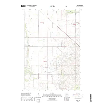
2018 Map of Venlo
USGS Topo · Published 2018About this map
Venlo sits at a distinct diagonal intersection of rail and road, serving as a focal point for the surrounding Ransom County agricultural landscape. The western portion of the area is defined by the winding course of the Sheyenne River, which is spanned by the Heaton Bridge. Much of the eastern and southern terrain transitions into the Sheyenne National Grassland, a sprawling expanse of prairie and wetland pockets. This 2018 survey captures a modern look at the region's recreational and conservation value, notably featuring the N Country National Scenic Trail as it meanders through the grasslands and past landmarks like Pigeon Point. The map provides a detailed view of the township grid and section lines that define this portion of North Dakota, from t135n r54w down to t134n r53w.
Find a feature on this map
17 named features on this map. Tap any name to fly to it.
Don’t see what you’re looking for? This feature index may not catch every label — zoom into the map to look around manually.
Map Details
Editions of this 2018 Venlo Map
This is the sole edition of this map. No revisions or reprints were ever made.
Other maps of this area

1895 · Casselton
USGS Topo · 1:125,000

1897 · Tower
USGS Topo · 1:125,000

1897 · Casselton
USGS Topo · 1:125,000

1907 · Wyndmere
USGS Topo · 1:125,000

1953 · Fargo
USGS Topo · 1:250,000

1956 · Fargo
USGS Topo · 1:250,000

1960 · Lisbon SE
USGS Topo · 1:24,000

1960 · Coburn
USGS Topo · 1:24,000

1960 · De Lamere
USGS Topo · 1:24,000

1960 · Lisbon NE
USGS Topo · 1:24,000