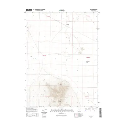
2014 Map of Ventosa
USGS Topo · Published 2014About this map
Ventosa sits at the northern end of this Elko County landscape, marking a point of interest where the high desert terrain transitions between distinct valley systems. The topographical detail reveals the sharp rise of Spruce Mtn Ridge and Spruce Point, providing a clear view of the elevation changes that define this part of the Great Basin. To the west, Clover Valley occupies the lowland, while Independence Valley stretches to the east, separated by the prominent Black Ridge. Water features are scarce in this arid environment, making The Slough, Point Spring, and the drainage of Steele Cr critical landmarks for understanding the historical movement of livestock and travelers through the region. This 2014 survey captures the enduring isolation of the area, defined more by its natural landmarks and township boundaries than by modern development.
Find a feature on this map
15 named features on this map. Tap any name to fly to it.
Don’t see what you’re looking for? This feature index may not catch every label — zoom into the map to look around manually.
Map Details
Editions of this 2014 Ventosa Map
This is the sole edition of this map. No revisions or reprints were ever made.
Other maps of this area

1953 · Spruce Mountain
USGS Topo · 1:62,500

1953 · Spruce Mountain 4
USGS Topo · 1:62,500

1955 · Elko
USGS Topo · 1:250,000

1958 · Elko
USGS Topo · 1:250,000

1962 · Elko
USGS Topo · 1:250,000

1965 · Elko
USGS Topo · 1:250,000

1968 · Independence Valley SW
USGS Topo · 1:24,000

1968 · Snow Water Lake
USGS Topo · 1:24,000

1968 · Ventosa
USGS Topo · 1:24,000
1968 · Snow Water Lake NE
USGS Topo · 1:24,000