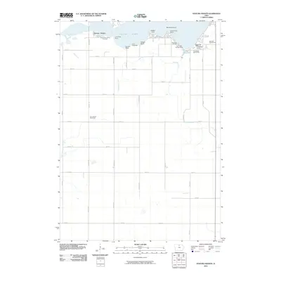
2010 Map of Ventura Heights
USGS Topo · Published 2010About this map
The northern shoreline of Clear Lake dominates this 2010 landscape, where the settlement of Ventura Heights meets a concentrated network of recreation and leisure sites. This area serves as a primary hub for summer activity in Cerro Gordo County, evidenced by the dense cluster of Open Bible Camp Grounds, Camp Tanglefoot, and private recreation areas like Dodges Beach and Farmers Beach. The map illustrates the specialized infrastructure of the lakefront economy, from the Sunset Bay Marina to several lakeside campgrounds including Twin Oaks Campgrounds and the Oakwood RV Park.
Find a feature on this map
39 named features on this map. Tap any name to fly to it.
Don’t see what you’re looking for? This feature index may not catch every label — zoom into the map to look around manually.
Map Details
Editions of this 2010 Ventura Heights Map
This is the sole edition of this map. No revisions or reprints were ever made.
Other maps of this area

1954 · Mason City
USGS Topo · 1:250,000

1954 · Waterloo
USGS Topo · 1:250,000

1955 · Waterloo
USGS Topo · 1:250,000

1957 · Mason City
USGS Topo · 1:250,000

1958 · Mason City
USGS Topo · 1:250,000

1972 · Clear Lake West
USGS Topo · 1:24,000

1972 · Thornton
USGS Topo · 1:24,000

1972 · Swaledale
USGS Topo · 1:24,000

1972 · Burchinal
USGS Topo · 1:24,000
1972 · Clear Lake East
USGS Topo · 1:24,000