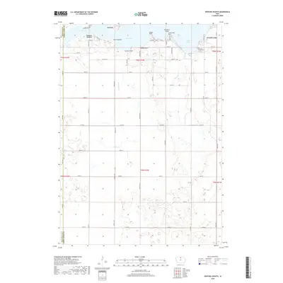
2018 Map of Ventura Heights
USGS Topo · Published 2018About this map
Clear Lake dominates the northern landscape of this region, serving as the focal point for the lakeside communities of Ventura and Ventura Heights. The shoreline is characterized by distinct geographic features such as Lone Tree Point, Dodges Point, and Grand View Point, while Woodford Island sits prominently within the water. This 2018 survey illustrates the established residential and recreational layout of the area, featuring Dodges Beach and Farmers Beach alongside a rigid grid of rural roads like Cardinal Ave and Dogwood Ave.
Find a feature on this map
56 named features on this map. Tap any name to fly to it.
Don’t see what you’re looking for? This feature index may not catch every label — zoom into the map to look around manually.
Map Details
Editions of this 2018 Ventura Heights Map
This is the sole edition of this map. No revisions or reprints were ever made.
Other maps of this area

1954 · Mason City
USGS Topo · 1:250,000

1954 · Waterloo
USGS Topo · 1:250,000

1955 · Waterloo
USGS Topo · 1:250,000

1957 · Mason City
USGS Topo · 1:250,000

1958 · Mason City
USGS Topo · 1:250,000

1972 · Clear Lake West
USGS Topo · 1:24,000

1972 · Thornton
USGS Topo · 1:24,000

1972 · Swaledale
USGS Topo · 1:24,000

1972 · Burchinal
USGS Topo · 1:24,000
1972 · Clear Lake East
USGS Topo · 1:24,000