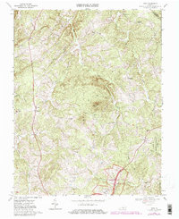
1968 Map of Vera
USGS Topo · Published 1980About this map
The Appomattox Court House National Historical Park anchors the southern portion of this landscape, preserving the site of the historic 1865 surrender. The map highlights the McLean House, a central landmark of the Civil War’s end, situated near the headwaters of the Appomattox River. To the northeast, the terrain transitions into the dense woodlands of the Appomattox-Buckingham State Forest.
Find a feature on this map
34 named features on this map. Tap any name to fly to it.
Don’t see what you’re looking for? This feature index may not catch every label — zoom into the map to look around manually.
Map Details
Editions of this 1968 Vera Map
Other maps of this area

1892 · Buckingham
USGS Topo · 1:125,000

1892 · Appomattox
USGS Topo · 1:125,000

1947 · Roanoke
USGS Topo · 1:250,000

1958 · Appomattox
USGS Topo · 1:62,500

1958 · Pamplin City
USGS Topo · 1:62,500

1959 · Roanoke
USGS Topo · 1:250,000

1961 · Shipman
USGS Topo · 1:62,500

1961 · Buckingham
USGS Topo · 1:62,500

1963 · Roanoke
USGS Topo · 1:250,000
1968 · Concord
USGS Topo · 1:24,000