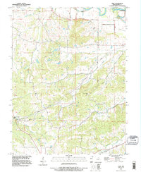
1991 Map of Vera
USGS Topo · Published 1995About this map
The Salt River meanders across the northeastern corner of this Pike County landscape, where the Reading settlement sits near the Ted Shanks State Conservation Area. This region is defined by a series of significant drainage systems, including Sugar Creek, Noix Creek, and Cains Creek, which carve through the terrain and influence the placement of early homesteads and landmarks. The map serves as a vital record for genealogists, as it documents numerous family-named burial grounds dispersed throughout the hills, such as Early Cem, Euell Cem, Arthur Cem, and Fairview Cem. In the south, the community of Vera and the McElwee Cem anchor the area near Little Noix Creek. Modern infrastructure is represented by a Gaging Station and several towers, while the presence of a Pit suggests local industrial activity. The intricate network of rural roads and watercourses like Galley Branch and Grassy Creek reveals the historical settlement patterns of this Missouri river valley.
Find a feature on this map
22 named features on this map. Tap any name to fly to it.
Don’t see what you’re looking for? This feature index may not catch every label — zoom into the map to look around manually.
Map Details
Editions of this 1991 Vera Map
This is the sole edition of this map. No revisions or reprints were ever made.
Other maps of this area

1890 · Louisiana
USGS Topo · 1:125,000

1931 · Barry
USGS Topo · 1:62,500

1932 · Hannibal
USGS Topo · 1:62,500

1936 · Hannibal
USGS Topo · 1:48,000

1936 · Barry
USGS Topo · 1:48,000

1937 · Bowling Green
USGS Topo · 1:62,500

1940 · Bowling Green
USGS Topo · 1:62,500

1943 · Vandalia
USGS Topo · 1:62,500

1944 · Barry
USGS Topo · 1:62,500

1945 · Hannibal
USGS Topo · 1:62,500