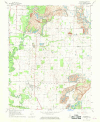
1968 Map of Vergennes
USGS Topo · Published 1970About this map
The Illinois Central Railroad corridor anchors the landscape of southern Illinois in the late 1960s, connecting the village of Vergennes with rural outposts like Matthews Junction and Walkers. The terrain is defined by the winding course of Beaucoup Creek, which flows through a region transitioning from agricultural use to industrial excavation. Evidence of local extraction is visible in the prominent Strip Mine operations and extensive Tailings piles that flank the rail lines and creek beds, illustrating the era's intensive resource recovery.
Find a feature on this map
24 named features on this map. Tap any name to fly to it.
Don’t see what you’re looking for? This feature index may not catch every label — zoom into the map to look around manually.
Map Details
Editions of this 1968 Vergennes Map
This is the sole edition of this map. No revisions or reprints were ever made.
Other maps of this area

1910 · Herrin
USGS Topo · 1:62,500

1910 · Murphysboro
USGS Topo · 1:62,500

1924 · Pinckneyville
USGS Topo · 1:62,500

1926 · Pinckneyville
USGS Topo · 1:62,500

1926 · Duquoin
USGS Topo · 1:62,500

1936 · Herrin
USGS Topo · 1:62,500

1938 · Murphysboro
USGS Topo · 1:62,500

1949 · Paducah
USGS Topo · 1:250,000

1950 · Paducah
USGS Topo · 1:250,000

1954 · Paducah
USGS Topo · 1:250,000