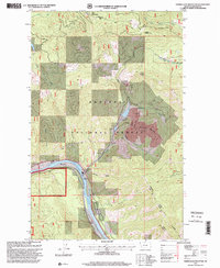
1997 Map of Vermiculite Mountain
USGS Topo · Published 2000About this map
Vermiculite Mountain dominates this landscape within the Kootenai National Forest, revealing the industrial footprint of timber and mining operations in the late 20th century. The intricate network of extraction is visible through labels for a Mine Dump, Gravel Pits, and a Tramway near the area of Fleetwood. The natural topography is defined by the sweeping curve of the Kootenai River, which is supported by infrastructure including a Pumping Station and Storage Bins. While much of the terrain is characterized by deep drainages like Thomas Gulch and Kennedy Gulch, the presence of Bakker Ranch near the riverbank provides a point of reference for local settlement. High-elevation vantage points are noted at Blue Mountain and a dedicated Lookout, overlooking the confluence of mountain creeks such as Rainy Creek and the Fisher River.
Find a feature on this map
28 named features on this map. Tap any name to fly to it.
Don’t see what you’re looking for? This feature index may not catch every label — zoom into the map to look around manually.
Map Details
Editions of this 1997 Vermiculite Mountain Map
This is the sole edition of this map. No revisions or reprints were ever made.
Other maps of this area

1920 · Libby
USGS Topo · 1:125,000

1920 · Jennings
USGS Topo · 1:125,000

1930 · Libby
USGS Topo · 1:125,000

1932 · Libby
USGS Topo · 1:125,000

1935 · Thompson Lakes
USGS Topo · 1:96,000

1942 · Thompson Lakes
USGS Topo · 1:125,000

1957 · Kalispell
USGS Topo · 1:250,000

1960 · Kalispell
USGS Topo · 1:250,000

1961 · Kalispell
USGS Topo · 1:250,000

1963 · Vermiculite Mountain
USGS Topo · 1:24,000