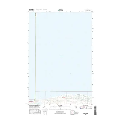
2017 Map of Vermilion
USGS Topo · Published 2017About this map
Lake Superior dominates this northern coastal landscape, its shoreline defining the boundary of the Upper Peninsula at the border of Luce and Chippewa Counties. Near the southern edge of the sheet, the settlement of Vermilion sits along the shoreline, marking a historical point of human activity in this expansive maritime environment. The terrain is characterized by intricate wetland patterns and subtle elevation changes as the land rises from the lake shore towards the interior. This survey provides a precise look at the 2017 shoreline configuration and the relative isolation of the settlements before modern development patterns significantly altered the coastal stretch.
Find a feature on this map
3 named features on this map. Tap any name to fly to it.
Don’t see what you’re looking for? This feature index may not catch every label — zoom into the map to look around manually.
Map Details
Editions of this 2017 Vermilion Map
This is the sole edition of this map. No revisions or reprints were ever made.
Other maps of this area

1951 · Vermilion SE
USGS Topo · 1:24,000

1951 · Shelldrake
USGS Topo · 1:24,000

1951 · Vermilion
USGS Topo · 1:24,000

1951 · Sheephead Lake
USGS Topo · 1:24,000

1951 · Shelldrake
USGS Topo · 1:62,500

1954 · Sault Sainte Marie
USGS Topo · 1:250,000

1956 · Sault Sainte Marie
USGS Topo · 1:250,000

1957 · Sault Sainte Marie
USGS Topo · 1:250,000

1958 · Sault Sainte Marie
USGS Topo · 1:250,000
1968 · Betsy Lake North
USGS Topo · 1:24,000