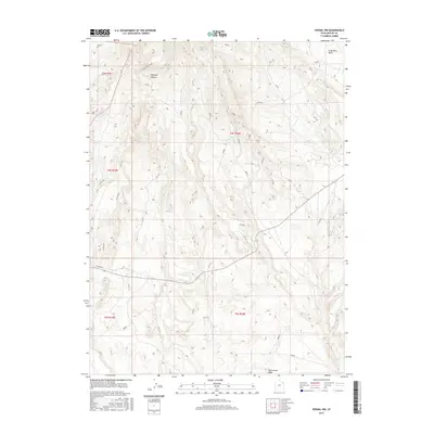
2017 Map of Vernal NW
USGS Topo · Published 2017About this map
Coal Mine Basin dominates the northeastern corner of this Uintah County landscape, reflecting the region's industrial ties to the earth. The terrain transitions from the high elevations of Halfway Hollow down toward the drainage of Twelvemile Wash in the south. This 2017 survey by the U.S. Geological Survey details a high-desert environment defined by sparse but vital water sources, such as Cottonwood Spring and the C C C Tank. The Public Land Survey System grid is clearly marked across the landscape, including township boundaries like t4s r20e and t5s r20e. Accessibility is noted along high ridges via the Little Mountain Rim Rd, which follows the natural contours of the plateau to provide passage through this drainage-heavy territory.
Find a feature on this map
11 named features on this map. Tap any name to fly to it.
Don’t see what you’re looking for? This feature index may not catch every label — zoom into the map to look around manually.
Map Details
Editions of this 2017 Vernal NW Map
This is the sole edition of this map. No revisions or reprints were ever made.
Other maps of this area

1885 · Ashley
USGS Topo · 1:250,000

1906 · Marsh Peak
USGS Topo · 1:125,000

1908 · Marsh Peak
USGS Topo · 1:125,000

1917 · Vernal
USGS Topo · 1:125,000

1954 · Vernal
USGS Topo · 1:250,000

1958 · Vernal
USGS Topo · 1:250,000

1960 · Vernal
USGS Topo · 1:250,000

1964 · Vernal NE
USGS Topo · 1:24,000
1964 · Fort Duchesne
USGS Topo · 1:24,000

1964 · Lapoint
USGS Topo · 1:24,000