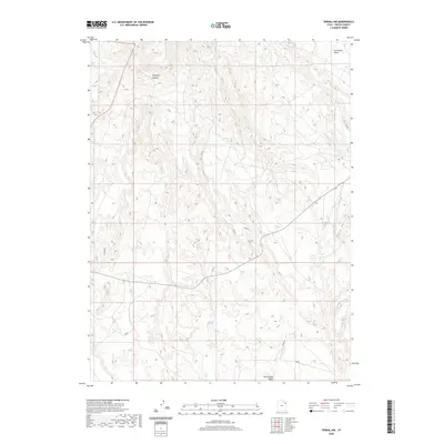
2020 Map of Vernal NW
USGS Topo · Published 2020About this map
Halfway Hollow defines the arid, high-desert landscape of this corner of Uintah County, where complex topography and seasonal drainages dominate the terrain. A network of primitive roads and 4WD tracks, such as 012107 and 012110, crisscross the basin, indicating the region's continued importance for resource access and grazing. The presence of Cottonwood Spring provides a rare point of perennial water in an otherwise parched environment characterized by significant geological depressions and rises. In the northeast, the presence of Coal Mine Basin suggests a history of local mineral extraction, while the winding Twelvemile Wash to the south and the curiously named Corkscrew feature in the west highlight the erosional forces that have shaped this portion of the Uinta Basin.
Find a feature on this map
16 named features on this map. Tap any name to fly to it.
Don’t see what you’re looking for? This feature index may not catch every label — zoom into the map to look around manually.
Map Details
Editions of this 2020 Vernal NW Map
This is the sole edition of this map. No revisions or reprints were ever made.
Other maps of this area

1885 · Ashley
USGS Topo · 1:250,000

1906 · Marsh Peak
USGS Topo · 1:125,000

1908 · Marsh Peak
USGS Topo · 1:125,000

1917 · Vernal
USGS Topo · 1:125,000

1954 · Vernal
USGS Topo · 1:250,000

1958 · Vernal
USGS Topo · 1:250,000

1960 · Vernal
USGS Topo · 1:250,000

1964 · Vernal NE
USGS Topo · 1:24,000
1964 · Fort Duchesne
USGS Topo · 1:24,000

1964 · Lapoint
USGS Topo · 1:24,000