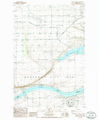
1986 Map of Vernita Bridge
USGS Topo · Published 1986About this map
Columbia River waters divide this mid-1980s landscape, separating the rugged topography of the Saddle Mountain range from the highly controlled industrial and ecological zones of south-central Washington. The northern portion of the map is dominated by the Wahluke Slope, featuring infrastructure for land management such as the Wahluke Slope Habitat Management Area and a network of transmission lines and storage bins. Central to the map's identity is the Saddle Mountain National Wildlife Refuge, which provides a protected buffer between the agricultural slopes and the high-security operations to the south.
Find a feature on this map
20 named features on this map. Tap any name to fly to it.
Don’t see what you’re looking for? This feature index may not catch every label — zoom into the map to look around manually.
Map Details
Editions of this 1986 Vernita Bridge Map
This is the sole edition of this map. No revisions or reprints were ever made.
Other maps of this area

1911 · Red Rock
USGS Topo · 1:62,500

1912 · Beverly
USGS Topo · 1:62,500

1916 · Coyote Rapids
USGS Topo · 1:62,500

1917 · Priest Rapids
USGS Topo · 1:62,500

1948 · Emerson Nipple
USGS Topo · 1:24,000

1950 · Smyrna
USGS Topo · 1:62,500

1951 · Priest Rapids
USGS Topo · 1:62,500

1951 · Smyrna
USGS Topo · 1:62,500

1951 · Coyote Rapids
USGS Topo · 1:62,500

1953 · Walla Walla
USGS Topo · 1:250,000