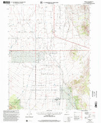
1998 Map of Vernon
USGS Topo · Published 2002About this map
Vernon sits at the edge of the arid Rush Valley, serving as a gateway to the high elevations of the Wasatch National Forest. This high-desert landscape is defined by the transition from open valley floor to the prominent Sheeprock Mountains in the south. The mapping highlights the intersection of local history and public land management, notably marking the Chief Green Jacket Grave and the Benmore (Site), a former settlement now associated with the Benmore Work Center. Water remains the critical factor for survival and settlement here, with several seasonal drainages like Vernon Creek, Bennion Creek, and Government Creek descending from the mountains to feed the valley's cattle-grazing land. The grid of the public land survey system is clearly visible, showing how the territory was organized for ranching and forest administration in Tooele County.
Find a feature on this map
25 named features on this map. Tap any name to fly to it.
Don’t see what you’re looking for? This feature index may not catch every label — zoom into the map to look around manually.
Map Details
Editions of this 1998 Vernon Map
This is the sole edition of this map. No revisions or reprints were ever made.
Other maps of this area

1885 · Sevier Desert
USGS Topo · 1:250,000

1885 · Tooele Valley
USGS Topo · 1:250,000

1953 · Tooele
USGS Topo · 1:250,000

1953 · Delta
USGS Topo · 1:250,000

1955 · Tooele
USGS Topo · 1:250,000

1958 · Delta
USGS Topo · 1:250,000

1962 · Delta
USGS Topo · 1:250,000
1963 · Sabie Mountain
USGS Topo · 1:24,000
1963 · Dutch Peak
USGS Topo · 1:24,000

1971 · Vernon NE
USGS Topo · 1:24,000