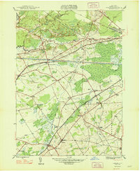
1948 Map of Verona
USGS Topo · Published 1948About this map
The Sand Plains and marshy lowlands of Oneida County define this 1940s landscape, where water management and industrial transit dominate the terrain. The coexistence of the Barge Canal and the Erie Canal (Abandoned) illustrates a pivotal era of New York infrastructure, with the older canal route visible near New London and the Fort Bull Mon landmark. This period shows a complex network of rural hamlets and named intersections such as Seifert Corners, Agnes Corners, and Stooks Corners, reflecting the intensive agricultural and residential settlement of the Verona and Rome boundaries.
Find a feature on this map
50 named features on this map. Tap any name to fly to it.
Don’t see what you’re looking for? This feature index may not catch every label — zoom into the map to look around manually.
Map Details
Editions of this 1948 Verona Map
This is the sole edition of this map. No revisions or reprints were ever made.
Other maps of this area

1895 · Oriskany
USGS Topo · 1:62,500

1895 · Oneida
USGS Topo · 1:62,500

1898 · Oneida
USGS Topo · 1:62,500

1898 · Oriskany
USGS Topo · 1:62,500

1902 · Oneida
USGS Topo · 1:62,500

1904 · Boonville
USGS Topo · 1:62,500

1905 · Taberg
USGS Topo · 1:62,500

1939 · Oneida
USGS Topo · 1:62,500

1943 · Camden East
USGS Topo · 1:31,680

1943 · Lee Center
USGS Topo · 1:31,680