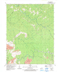
1992 Map of Vest
USGS Topo · Published 1992About this map
Quicksand Creek winds through the heart of this East Kentucky landscape, where narrow valleys and steep hollows dictate the pattern of settlement. Remote communities like Vest, Decoy, and Elmrock are tucked into the drainages of Balls Fork and the Wet Fork, many centered around local institutions such as the Beckham Combs Sch and Decoy Sch. The terrain is marked by numerous family-named landmarks and hollows, including Miller Hollow, Coles Hol, and Goff Hollow, reflecting generations of residence in the Cumberland Plateau region. Industrial activity is visible in the southwestern corner, where several large strip mines and gas wells have altered the natural topography. High points like Potato Knob and White Oak Ridge overlook a complex network of branches and forks, such as Buckhorn Creek and Laurel Fork, which continue to define the geography of this rural coalfield area.
Find a feature on this map
102 named features on this map. Tap any name to fly to it.
Don’t see what you’re looking for? This feature index may not catch every label — zoom into the map to look around manually.
Map Details
Editions of this 1992 Vest Map
This is the sole edition of this map. No revisions or reprints were ever made.
Other maps of this area

1886 · Prestonsburg
USGS Topo · 1:125,000

1889 · Salyersville
USGS Topo · 1:125,000

1890 · Whitesburg
USGS Topo · 1:125,000

1891 · Hazard
USGS Topo · 1:125,000

1891 · Salyersville
USGS Topo · 1:125,000

1892 · Whitesburg
USGS Topo · 1:125,000

1892 · Prestonsburg
USGS Topo · 1:125,000

1899 · Salyersville
USGS Topo · 1:125,000

1912 · Hindman
USGS Topo · 1:48,000

1914 · Troublesome
USGS Topo · 1:62,500