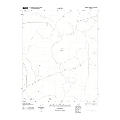
2010 Map of Veteado Mountain
USGS Topo · Published 2010About this map
Veteado Mountain and Techado Mountain anchor this high-elevation landscape in Cibola County, where the topography is defined by a network of seasonal drainage patterns and traditional cattle ranching outposts. This 2010 survey illustrates a sparsely populated region of New Mexico characterized by working ranch lands, including the McNab Ranch, Black Ranch, and Green Ranch. The settlement pattern relies heavily on remote camps like Hubbell Camp and water sources such as Tingle Well and Dutch Lake.
Find a feature on this map
19 named features on this map. Tap any name to fly to it.
Don’t see what you’re looking for? This feature index may not catch every label — zoom into the map to look around manually.
Map Details
Editions of this 2010 Veteado Mountain Map
This is the sole edition of this map. No revisions or reprints were ever made.
Other maps of this area

1954 · Saint Johns
USGS Topo · 1:250,000

1957 · Saint Johns
USGS Topo · 1:250,000

1958 · Saint Johns
USGS Topo · 1:250,000

1962 · Saint Johns
USGS Topo · 1:250,000

1967 · Mariano Springs
USGS Topo · 1:24,000

1967 · Chimney Hill
USGS Topo · 1:24,000

1967 · Adams Diggings
USGS Topo · 1:24,000

1967 · Blue Hills
USGS Topo · 1:24,000

1967 · Veteado Mountain
USGS Topo · 1:24,000
1967 · Cerro Pomo
USGS Topo · 1:24,000