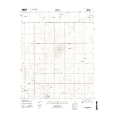
2013 Map of Veteado Mountain
USGS Topo · Published 2013About this map
Veteado Mtn rises as the dominant landmark along the Cibola Co Catron Co line in this high-desert landscape of western New Mexico. The terrain is defined by a complex network of arroyos and canyons, including the prominent Horse Camp Canyon and the deep incisions of Wyche Canyon and Pine Canyon to the south. The distribution of remote ranching outposts such as McNab Ranch, Black Ranch, and Green Ranch highlights the traditional land use in this arid region, where water sources like Dutch Lake and Tingle Well were vital for livestock and survival.
Find a feature on this map
28 named features on this map. Tap any name to fly to it.
Don’t see what you’re looking for? This feature index may not catch every label — zoom into the map to look around manually.
Map Details
Editions of this 2013 Veteado Mountain Map
This is the sole edition of this map. No revisions or reprints were ever made.
Other maps of this area

1954 · Saint Johns
USGS Topo · 1:250,000

1957 · Saint Johns
USGS Topo · 1:250,000

1958 · Saint Johns
USGS Topo · 1:250,000

1962 · Saint Johns
USGS Topo · 1:250,000

1967 · Mariano Springs
USGS Topo · 1:24,000

1967 · Chimney Hill
USGS Topo · 1:24,000

1967 · Adams Diggings
USGS Topo · 1:24,000

1967 · Blue Hills
USGS Topo · 1:24,000

1967 · Veteado Mountain
USGS Topo · 1:24,000
1967 · Cerro Pomo
USGS Topo · 1:24,000